
Running from the Smoke: Our Flight to the Coast
A wildfire ignites just outside of Mount Rainier National Park
The world was on fire.
Or at least, the mountains in the Western USA were.
The smoke in the air was seemingly inescapable this summer. The air quality map became the most-checked reference on my phone, before even the weather. I found myself asking not if the air was clear, but how smoky it would be today, and if it would be too smoky to bear.
One advantage of living in a van full-time is that if the weather changes for the worse, we can hop into the front seats and hit the pavement to what will hopefully be a more comfortable destination. Whether that means fleeing from the heat, fleeing from the cold, or seeking out dry weather—we can go wherever the weather is most optimal. (That is, if we aren't committed to staying in a specific area for work or another obligation.)
One major disadvantage that we didn't consider when we moved into the van is that, unless you're driving between destinations, the van is constantly filled with and circulating whatever air is in the outside environment. While this can pose an obvious cooling challenge when temps soar in the heat of the summer, we didn't consider how it would affect us when the air fills with smoke.
When the weather is hot, running the fans to pull air through the van is necessary to keep the living space from overheating. But if it's smoky outside, those fans pull the smoke straight into the living area, meaning that we're breathing the smoky air 100% of the time.
If you live in a house or an apartment, you'll most likely have an air conditioning unit with air filters. This AC unit will not only cool the house, but keeping the windows closed and circulating air through the AC unit and air filter keeps the vast majority of the smoke outside of the house, and the air inside clean and easy on the lungs.
In a van, you're at the mercy of the elements. And the elements this summer were hellish.
Fleeing from the Smoke
We spent three weeks in Montana exploring the best singletrack trails the region had to offer while on assignment for FATMAP, and smoke was our companion the entire time. The only question was how thick the smoke would be on a given day. On rare days, the smoke would lift just a little bit, revealing majestic mountain peaks in the distance that we hadn't seen before, despite driving the same roads every day for a week.
As our stay in Montana wound down, we decided to flee the smoke. While we had originally hoped to explore a set of remote mountain ranges in Idaho, our desired destination had lit on fire since our arrival in Montana. We scrapped those plans and set our sights for a green spot on the air quality map that had been on our to-do list for years: Mount Rainier National Park.
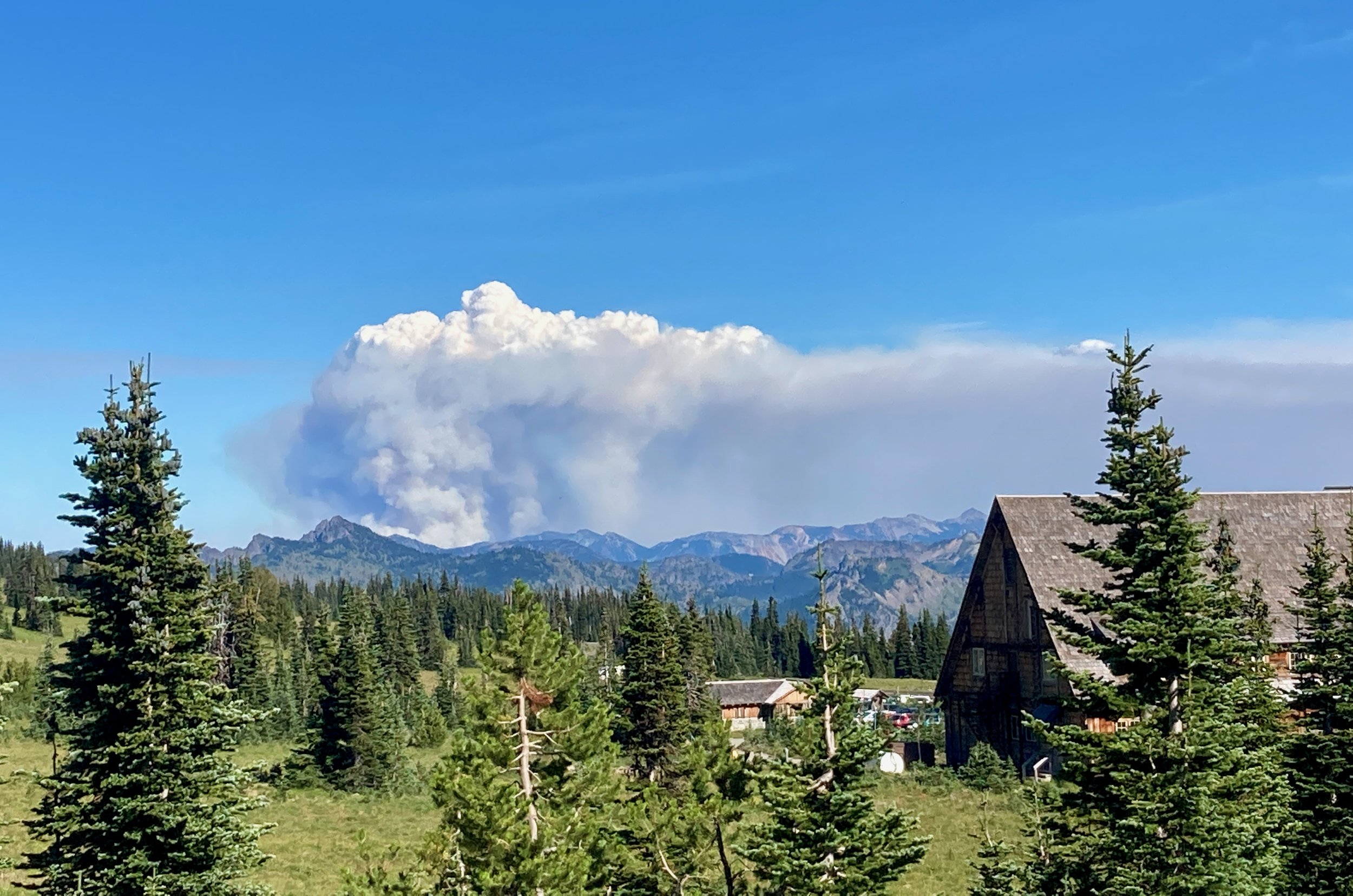
After rolling into the White River campground, we booked a campsite for a solid 7 nights. Unfortunately, after two clear days, we spotted a fire that had ignited outside of the national park, the mushroom cloud of smoke quickly ballooning into the air. Since the smoke cloud was rising to the east, and the prevailing winds would push the smoke away, we weren't too worried.

The wildfire, shortly after igniting and just an hour or so before the featured photo above.
Our optimistic outlook was soon destroyed. During the third night in Mount Rainier, the wind changed, pushing the smoke into the park. We awoke to dim views of the mountain and tried to make the best of the day. Upon returning to the campsite in the afternoon, Mount Rainier was entirely obscured in smoke.
That night, I woke several times to hear Christine coughing in her sleep—a direct result of the harsh smoke assaulting our lungs for days on end.
It was time to run again.
Out to the Coast
As we examined the air quality map, we realized our options were limited due to an appointment that we had to make it to in Medford, Oregon, in a couple of weeks. Unfortunately, Medford was at the epicenter of one of the worst smoke clouds in the nation, thanks to a massive fire in the Klamath National Forest. We had planned to spend a week mountain biking in Hood River, but the same smoke cloud that pushed us out of Mount Rainier was inundating Hood River as well.
The air quality map had turned into a mottled painting of orange, red, and yellow hues of lung-searing smoke. We chose the only green spot within 500 miles and hit the road. Destination: the Oregon Coast.
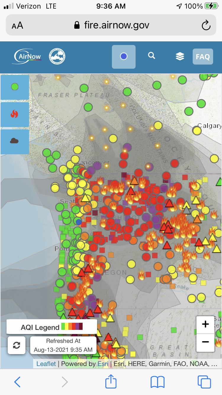
An example screenshot of the air quality map from this summer. I’d spend hours staring at the map, trying to figure out how to navigate our way through the inferno.
After spending 7 months living in Oregon the previous year, we had tasted the beauty of the Oregon Coast. The promise of cool temps and clean air blowing in off the ocean was a beacon drawing us out of a fiery hell and into the promised land.
Originally, we had hoped to stop in the Coast Range a few miles shy of the actual coast to check out a few trails, but a second heatwave with temps over 100 degrees struck Oregon at the exact same time. As we pulled into the Coast Range, the external thermometer still read 94 degrees. I turned to Christine and said, "I'm not stopping this van until the temperature drops." We kept following the road inexorably westward, searching for a break from this madness.
After crossing through the heart of the Coast Range, we began our descent to the Pacific Ocean. As we drove down a small mountain pass, the temperature gauge began to drop... slowly at first, and then dramatically as we drove into the cool rainforest along the coast.
When we finally stopped, the thermometer read 67 degrees, without a hint of smoke in sight.
At last! After months of searing heat, choking smoke, and biting bugs, we had found a respite in the damp rainforests next to the crashing surf of Oregon's beautiful, wild coastline.

We made it!